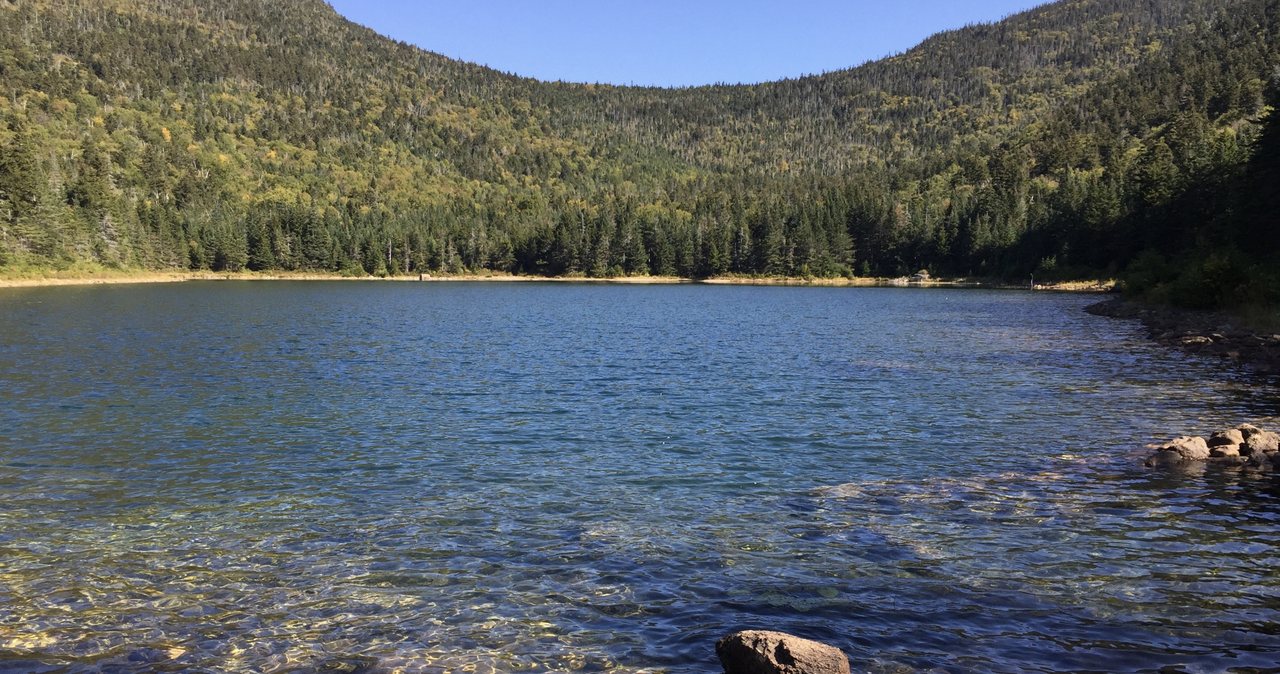
Most people who drive Tripoli Road are heading for Mount Osceola or the roadside campsites, and they pass the East Pond trailhead without a glance. That is a mistake we are happy to correct. From a small lot about five miles up the gravel road, the East Pond Trail climbs gently for 1.4 miles along an old logging railroad grade to East Pond, a clear, cold tarn at about 2,600 feet with the ledges of Scar Ridge rising behind it. Sit on the rocks at the outlet and you will usually have the place to yourself.
The pond alone is a fine two-and-a-half-hour outing. Add the loop over to Little East Pond, a smaller, wilder pond a mile and a half west, and back down the Little East Pond Trail to the road, and you have a hike of about 4.9 miles and roughly 1,000 feet of climbing that feels far more remote than the numbers suggest. It is the kind of walk that reminds you the White Mountains are not only summits.
This guide covers the route in both directions, the seasonal gate on Tripoli Road that shuts the trailhead for half the year, the parking and the fee situation, fishing and swimming in the ponds, the longer through-hike to the Kancamagus for anyone with two cars, and the bugs, mud and moose you should plan around. The trailhead is about 15 min from our door.
The numbers
East Pond is 1.4 miles from the Tripoli Road trailhead on the East Pond Trail, a steady, gentle climb of a few hundred feet on a wide old grade. The full loop, East Pond Trail to the pond, the East Pond Loop trail across to Little East Pond, and the Little East Pond Trail back down to the road, runs about 4.8 to 4.9 miles with roughly 1,000 to 1,050 feet of total elevation gain. Most people walk it in two and a half to three hours with time at both ponds.
The trailhead sits around 1,800 feet, East Pond near 2,600, and the connecting trail between the ponds climbs a little higher before dropping to Little East Pond. The East Pond Trail itself keeps going north past the pond, over the height of land at about 2.2 miles, and down the far side to the Kancamagus Highway at 5.1 miles, which makes a one-way traverse possible if you have two cars.
Getting to the trailhead: Tripoli Road and its gate
Tripoli Road is the gravel Forest Service road that runs east from I-93 at Exit 31, one exit south of Lincoln, over Thornton Gap to Waterville Valley. The East Pond trailhead is on the north side of the road about five miles in from the interstate, marked with a Forest Service sign and a small parking area. From the Waterville Valley side, it is roughly 4.6 miles up Tripoli Road from Route 49. The road is rough in places but fine for an ordinary car when it is open.
The word that matters is when. Tripoli Road is a seasonal road, gated and unplowed through the winter and into spring, typically from November until sometime in May depending on the snow. When the gate is closed the trailhead is several miles of road walk away and the loop turns into a long snowshoe. Check the White Mountain National Forest's road status before you drive up in late fall or spring; the dates follow the weather, not the calendar. In summer the road is also lined with dispersed roadside campsites, so expect campers and slow traffic on weekends.

Parking and the fee
The East Pond lot holds only a handful of cars and there is no overflow; on a sunny summer Saturday it can be full by mid-morning, though far later than the Osceola lot down the road. Park fully off the travel lane and do not block the gate or the road. Parking at this lot carries no listed fee, unlike most Kancamagus trailheads. Carry your White Mountain National Forest recreation pass anyway if you have one and read the kiosk on arrival, because fee sites change.
The trail to East Pond
The East Pond Trail leaves the road on the bed of an old logging railroad and stays wide and easy for most of the way. The grade is steady rather than steep, the footing is packed dirt with roots and a few wet spots, and the woods are a pleasant mix of hardwoods giving way to spruce as you climb. There are a couple of small brook crossings that are trivial in summer and worth a look in high water. About a mile in, the Little East Pond Trail junction is the point where the loop closes; continue straight for the pond.
East Pond announces itself with light through the trees. The trail meets the shore near the outlet, where flat rocks make the natural lunch spot, and a rough path continues around part of the pond. The water is clear and cold, the bottom is sandy and rocky near the outlet, and the view is straight up at the ledges and slides of Scar Ridge with the shoulder of Mount Osceola beyond. On a still morning the reflection is the photograph everyone takes home.
The loop: across to Little East Pond and back
From East Pond the connecting trail, signed as the East Pond Loop, climbs west over a low shoulder of Scar Ridge and drops to Little East Pond in about a mile and a half. This is the wildest stretch of the walk: narrower, rougher, more roots and mud, and quieter. Little East Pond is smaller and shallower than its neighbor, ringed with spruce and bog, and it feels like a place nobody has been in a week, which is often true.
The Little East Pond Trail then descends about 1.7 miles back to Tripoli Road, rejoining the East Pond Trail near the junction you passed on the way up, and the road walk back to the car is short. Most people do the loop counter-clockwise, East Pond first, so the big view arrives early and the quiet pond is the reward at the top. Either direction works; the climbing is gentle both ways.
Fishing and swimming in the ponds
East Pond holds brook trout and is fished from the rocks near the outlet, mostly by fly anglers in the early season and evenings. A New Hampshire fishing license is required for anyone sixteen and over; nonresident one-day and three-day licenses are sold online through New Hampshire Fish and Game, and the fly shop on Main Street in Lincoln can point you at the current rules. Check the state regulations for the pond before you fish; trout ponds carry their own seasons and limits.
Swimming is possible and cold. The water is mountain snowmelt and stays cold all summer; the outlet shallows are the only comfortable wading. Enter slowly, do not dive from the rocks, and keep in mind that there is no one around to help. Little East Pond is a bog pond, better for looking than swimming.
The through-hike to the Kancamagus
The East Pond Trail continues north past East Pond, climbs to a height of land at about 2.2 miles from Tripoli Road, and descends the far side of the ridge for another three miles to the Kancamagus Highway, 5.1 miles in all. The northern half is rougher and much less traveled, with some elevation loss and gain over the pass and a long walk down beside a brook. With two cars, one at each end, it is a fine one-way day that spits you out on the Kanc a short drive from the lodge. As a round trip from either end it is long for what you get; the loop is the better day.
Why the road is called Tripoli: the mill that dredged East Pond
The name puzzles everyone. Tripoli is an old trade name for diatomaceous earth, a fine, gritty deposit of fossil algae that was used a century ago as a polishing powder for silver and for cleaning the plates of early photographers. There is a bed of it on the bottom of East Pond, and from 1911 to 1919 the Livermore Tripoli Company dredged the pond for it and dried and processed the material at a mill built beside the road, served by the Woodstock and Thornton logging railroad. The company was owned by Charles B. Henry, a son of the timber baron J. E. Henry whose logging railroads built Lincoln.
The deposit turned out to be full of impurities and the venture was short and unprofitable. The mill was abandoned, its foundations still sit in the woods off the road near Tripoli Mill, and when the Forest Service finished the through road over Thornton Gap in 1934 the name stuck. The quiet pond you eat lunch beside was, for eight years, an industrial site; the fact that you would never guess it is the whole point of the century since.
Bugs, mud and moose
Two ponds and a bog mean insects. From late May through early July the black flies and mosquitoes at the shoreline can be relentless in still weather; carry repellent and a head net and plan lunch on the breezy rocks. The trail is muddy in spring and after rain, especially between the ponds, and the roots are slick when wet. Moose use both ponds and the boggy connector; they are not aggressive by nature but a cow with a calf in June or a bull in the September rut deserves a very wide berth and a slow retreat, never a closer photograph.
Seasons
Late June through early October is the season, once the gate opens and the mud dries. July and August mornings are the best for a swim and the worst for bugs. Foliage reaches the ponds in the first week of October, a little before the valley floor in Lincoln, and the birches around East Pond against the spruce are worth the trip on their own. In winter, with Tripoli Road gated, the loop becomes a long snowshoe that starts miles from the trailhead; it is pretty and empty and only for people who want a full day.
Who this hike is for
Anyone who wants a real destination close to town without a summit slog: a first morning, a rest day, an afternoon when the ridges are in cloud. Couples who like quiet water. Anglers. People who have done the famous notch walks and want somewhere they have not heard of. It suits a picnic and a book better than almost any hike on this list.
It is not for anyone who needs a view from a height; the ponds are the view. And it is not a winter or early spring hike for most people, because the road is closed. For a pond walk that stays open when the gate is down, Lonesome Lake in Franconia Notch is the year-round alternative.
Safety & conditions
- Tripoli Road is seasonal and gated roughly November to May. Check the White Mountain National Forest road status before driving up in spring or fall; when the gate is closed the trailhead is a long road walk away and the loop becomes a full winter day.
- The connector between the ponds is the remote part of the loop: narrow, muddy, rooty and little traveled. Carry a map and know the junctions, because a wrong turn here adds miles rather than minutes.
- The ponds are cold mountain water all summer. Enter slowly, never dive from the rocks, and remember there is usually no one else around to help. Cold-water shock can incapacitate a strong swimmer in seconds.
- Moose use both ponds and the bog between them. Give any moose a wide berth, especially a cow with a calf in early summer or a bull in the fall rut, and back away slowly rather than closing in for a photograph.
- Black flies and mosquitoes at the shorelines are relentless from late May into July. Carry repellent, consider a head net, and eat lunch on the breezy rocks rather than in the trees.
- Cell service is unreliable on Tripoli Road and gone at the ponds. Download a map before leaving Lincoln, tell someone your plan, and consider the $25 hikeSafe card; New Hampshire can bill for a rescue caused by negligence under RSA 206:26-bb.
- The small brook crossings are trivial in summer but can run high after heavy rain or in snowmelt. If a crossing looks fast and deep, turn around; the pond will be there next week.
Where to stay for it
This is one of the shortest drives to a trailhead from our door. From 191 Pollard Road get on I-93 South at Exit 32 and take the very next exit, 31, for Tripoli Road. Head east on the gravel road for about five miles, past the roadside campsites, and watch for the East Pond trailhead sign on the left. Allow 15 min. In summer the road is slow behind campers; in winter and spring it is gated, and you should check before you go.
Because the loop is a half day, it pairs well with the rest of that side of Lincoln. Our guests often walk it in the morning, drive the rest of Tripoli Road over Thornton Gap into Waterville Valley for lunch, and come home on Route 49 and I-93. Or they save it for the afternoon after a lazy breakfast in town, which is exactly the kind of day a pond hike is made for.
Anglers should stop at the fly shop on Main Street on the way out for a license and a current word on the pond.
Useful links
- White Mountain National Forest: road status, alerts and passes
Check whether Tripoli Road is open before you drive up in spring or late fall. - New Hampshire Fish and Game: fishing licenses
Nonresident one-day, three-day and seven-day licenses are sold online; check the pond regulations. - hikeSafe: the code and the card
The six-point hiker responsibility code and the $25 / $35 voluntary card. - Our Mount Osceola guide, from the same road
The 4,000-footer whose trailhead is a few miles further up Tripoli Road. - Our Lonesome Lake guide
The year-round pond walk in Franconia Notch for the months when Tripoli Road is gated.
Sources & official info: trailfinder.info · whitemountainhistory.org · alltrails.com · fs.usda.gov · wildlife.nh.gov · hikesafe.com
— Launchpoint Lodge, From the lodge