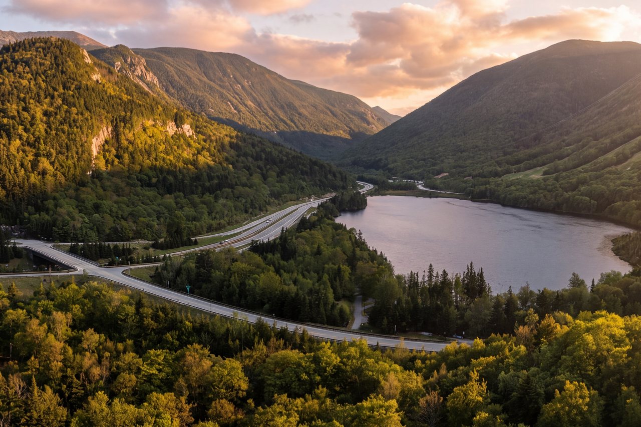
The Franconia Ridge Loop is the hike many people mean when they talk about the White Mountains. It runs close to nine miles with roughly 3,900 feet of climbing, and about a mile and a half of it walks a narrow open crest above treeline, with the Pemigewasset Wilderness falling away on one side and Franconia Notch and Cannon Mountain on the other. On a clear day it delivers three summits, a run of waterfalls, an AMC hut, and long views across the range. It is regularly cited on national lists of the best day hikes in the country, and the reputation is earned.
It also gets people hurt. The ridge is fully exposed, weather can change fast and turn cold, and the trailhead lots fill early. This guide is written by someone who lives about 15 min down the road and has walked this loop in summer heat, October wind, and winter snow. The aim is not to sell you on the mountain, but to tell you the things the trail sign and the app do not: where it gets hard, when to turn around, where the water is, which direction to hike it, and how to get a parking spot without a miserable early alarm.
If you are staying central in Lincoln, you have a real advantage on this hike, and most of it comes down to the short drive to the trailhead. We will get to that. First, the mountain.
The short version, before the detail
The standard loop starts and ends at Lafayette Place, a state-park trailhead right on the Franconia Notch Parkway (the stretch of I-93 that runs through the Notch). You climb the Falling Waters Trail — about 3.2 miles and roughly 3,050 feet of gain — past a series of waterfalls to the summit of Little Haystack Mountain at 4,780 feet. From there you turn north onto the Franconia Ridge Trail and walk the open crest about 1.7 miles (around 850 feet of additional gain) over Mount Lincoln at 5,089 feet to Mount Lafayette, the high point at 5,249 feet. You come off Lafayette on the Greenleaf Trail for a little over a mile to Greenleaf Hut, then descend the Old Bridle Path — about 2.9 miles from the hut — back to the parking area. The total is right around 8.9 miles, though published figures vary a little from source to source (roughly 8.5 to 9 miles).
Almost everyone hikes it counterclockwise, in that order: up Falling Waters, down Old Bridle Path. There are good reasons for that, which we will cover, but the short version is that going this way gets you to the exposed ridge earlier in the day and saves the gentler, more forgiving descent for tired legs.
Guidebook time for this loop is roughly eight hours. Fit, experienced hikers who keep moving can do it in five to six. Plenty of capable people who stop for photos, eat a real lunch on Lafayette, and are not in a hurry take eight, nine, or even ten hours, and that is fine as long as you start early enough to have the daylight. Plan for a full day. This is not a hike to squeeze in before an afternoon commitment.
Falling Waters Trail: the climb up
The loop begins on the east (northbound) side of the parkway. The Falling Waters Trail and the Old Bridle Path share the trailhead and run together for a short distance before splitting; follow the signed junction for the Falling Waters Trail when you want to go up past the waterfalls first. The trail is easy and nearly flat for the first half mile through hardwood forest, which can lull people into thinking the whole thing will be gentle. It will not be.
You cross Walker Brook and then reach Dry Brook, and the climbing begins in earnest. The waterfalls come in quick succession and are the reward for the steepening grade. Stairs Falls is first, a short, wide plunge. A little higher is Swiftwater Falls, about a 60-foot run of cascades. Then comes the main event: Cloudland Falls, an 80-foot horsetail fan and one of the better waterfalls you can reach on a hiking trail in the state. The trail climbs right alongside it. In late spring and after heavy rain these falls are loud and full; by late summer they can drop to a trickle. Either way this lower section is where the trail earns its name, and it is worth slowing down for even with a long day ahead.
There are several rock-hop brook crossings on the way up. In dry conditions they are straightforward, but the name Dry Brook is misleading in wet weather — when the brook is high after snowmelt or a storm, the crossings can be difficult, with slick rock and strong current. If you are looking at high water in spring, this is not the trail to push. Above Cloudland Falls the trail leaves the water, and the last stretch to the ridge is a steep, rooty, rocky grind through spruce and fir. A short signed side path partway up leads to Shining Rock, a large open granite slab that is worth the detour on a clear day and very slick when wet — many people pass it by and keep climbing.
The final push to Little Haystack is the steepest sustained section of the entire loop. You break out of the trees onto the summit of Little Haystack at 4,780 feet, and if the weather is good the ridge opens up to the north: Lincoln, then Lafayette, laid out ahead of you along the crest. This is the moment the hike becomes what it is known for. It is also the moment to make a hard, real decision about the weather, because everything past this point is exposed.

The ridge: Little Haystack to Lincoln to Lafayette
From Little Haystack you turn north onto the Franconia Ridge Trail, which is also the Appalachian Trail along this stretch. The next 1.7 miles are why people come. The path runs along a narrow open crest, in places only a few feet wide, with the ground dropping away steeply on both sides — the largely trailless Pemigewasset Wilderness to the east, the Notch and Cannon to the west. You are above treeline the entire way to Lafayette. There is no shade, no shelter, and nowhere to hide from wind or lightning.
The walking itself, in good conditions, is not technically hard. It is rocky and uneven, with some hand-on-rock scrambling near the summit of Mount Lincoln, but there is no cliff-edge climbing exposure — no pitches you have to climb. What makes it serious is simply that you are out in the open above 5,000 feet for a sustained stretch, and if conditions turn, you are committed. Mount Lincoln comes first, at 5,089 feet, a rugged little summit where the trail picks its way over blocky rock. Then the ridge dips and rises again toward Lafayette.
Mount Lafayette, at 5,249 feet, is the high point of the loop and one of the finest summits in the White Mountains. The stone foundation of an old summit house sits near the top, and on a clear day the views take in the Presidential Range to the northeast, the Twin and Bond ranges to the east, Franconia Notch and the Kinsmans to the west, and well into Vermont and Maine. This is where most people stop for a real lunch. It is also, on a busy summer Saturday, crowded — you may share the summit with dozens of others. If solitude is what you are after, this is not that hike; a weekday or an early start is the smarter play.
One practical note about the ridge: pace yourself for the wind and the sun, not just the terrain. People struggle on this section not because it is steep but because they have already climbed roughly 3,000 feet, the sun is beating down, and they run low on water. Eat and drink on the ridge before you feel you need to.
The descent: Greenleaf Hut and the Old Bridle Path
From the summit of Lafayette the loop continues on the Greenleaf Trail, dropping down the west shoulder of the mountain. This upper section is steep and rocky and stays above treeline for a while, so if weather is coming in, getting off the summit and down toward the hut is the priority. In a little over a mile you reach Greenleaf Hut at about 4,220 feet, sitting beside Eagle Lake, a small tarn, with the face of Lafayette rising behind it.
Greenleaf is one of the AMC's eight high-mountain huts, and for a day hiker it is a welcome stop. During its full-service season (roughly early June through mid-October — in 2026, about June 4 to October 17) the crew keeps the hut open in the daytime, refills water bottles and hot drinks, sells simple food such as soup and bread during midday hours, and has restrooms. Refilling here matters, because there is no reliable water on the ridge itself. Even if you do not need anything, it is a good place to sit for a few minutes, get out of the wind, and regroup before the final descent. If you ever want to make a night of it, the hut sleeps 48 in bunkrooms and serves family-style dinner and breakfast in season — book well ahead.
From the hut you pick up the Old Bridle Path for the last 2.9 miles down to the trailhead. This is the easier, more forgiving trail — a reasonable grade through the forest with a few open ledges partway down that give you one last look back up at the ridge you just walked. Do not let your guard down entirely, though; there is a section long known as Agony Ridge, a series of short, steep pitches on ledgy rock that are hard on tired knees and unpleasant when wet. Trekking poles earn their keep here. The Old Bridle Path rejoins the Falling Waters Trail near the bottom and returns you to the parking area.
A word on direction: you can do this loop the other way, up the Old Bridle Path and down Falling Waters, and some people prefer it. But descending the steep, wet, rock-hop waterfall trail at the end of a long day is how a lot of ankles get rolled and a lot of falls happen, especially in the afternoon when the light is fading. Going counterclockwise keeps the trickiest footing for fresh legs in the morning and saves the mellower trail for the end. Unless you have a specific reason, go up Falling Waters and down the Old Bridle Path.
How hard it is
This is a strenuous hike. Close to nine miles, roughly 3,900 feet of climbing, and hours of sustained effort on rough, rocky footing. It is not a beginner hike, and it is a poor choice as your first real mountain. If the longest you have walked recently is a flat three-mile loop, this will humble you — so carry plenty of water and keep energy in reserve for the exposed ridge.
Who this is for: reasonably fit people who hike regularly, are comfortable on their feet for six to nine hours, can handle steep rocky terrain up and down, and — this is the important part — have the judgment to turn around if the weather is wrong. You do not need to be an athlete. Plenty of ordinary people in decent shape do this loop every summer and have a great day. You do need stamina, sure footing, and honesty with yourself about conditions.
Who this is not for, at least not yet: young children, anyone with knee or ankle problems that steep descents aggravate, anyone uneasy about heights and open exposure, and anyone who has not built up to a full day on their feet. It is also a poor choice for a first hike of the season when your legs are not ready. There is no shame in saving it — the mountain will be here next year, and there are gentler ways to get a taste of the Notch first (Lonesome Lake and the flatter walking in the Notch are good warm-ups).
On timing, ignore the single number and think in ranges. Book time is about eight hours of moving and stopping. A strong, efficient party can go in five to six. Most fit-but-not-fast hikers who enjoy the summit and take photos land somewhere between seven and nine. Add time for a big group, hot weather, or a slower member — you go at the pace of your slowest person, always. Build the day around being back at the car with daylight to spare, which in practice means being on the trail early.
The trailhead and the parking reality
The trailhead is at Lafayette Place, on the Franconia Notch Parkway in Franconia Notch State Park. There are two small lots, one on each side of the divided parkway, connected by a walkway under the road; the hiker trailhead for Falling Waters and the Old Bridle Path is on the east (northbound) side. Because this is state-park land and not White Mountain National Forest, you do not need an America the Beautiful pass or the $5 WMNF recreation day pass to park here — those apply at some other trailheads in the Whites, but not at Lafayette Place. Day-use parking at the trailhead lots has been free; the state has discussed adding day-use parking fees in Franconia Notch in recent years, so if a current fee matters to your budget, confirm the latest with NH State Parks (603-823-8800) before you go.
Here is the hard truth: the lots are small and they fill early. On any decent summer or fall weekend, Lafayette Place is full by 7 to 8 a.m., sometimes earlier during peak foliage. When it fills, it fills — you cannot legally park along the parkway, and you may not park in the campground or at campsites. People who arrive at 9 on a Saturday in October are turned away and end up circling or driving off to another hike, having lost the morning.
There are two ways to beat this. The first is simply to be early. If you are on the trail by 6:30 or 7 a.m., you will get a spot and, as a bonus, the best light and the coolest walking. The second is the hiker shuttle: on Saturdays, Sundays, and holidays, roughly late May through mid-October (May 23 to October 18 in 2026), NH State Parks runs a shuttle between the overflow lot at Cannon Mountain (Exit 34B) and the Lafayette Place trailhead. It costs $5 per person round trip, dogs ride free, and it runs about 8 a.m. to 7 p.m. If you are getting a late start on a busy day, park at the Cannon lot and take the shuttle rather than gambling on Lafayette Place. Note that Cannon's aerial tramway itself is retired, with no reopening date announced, so it is not running — but the overflow lot and the shuttle still operate as usual.
This is where staying central in Lincoln pays off in a way that is easy to underestimate. The drive from town to Lafayette Place is about 12 min. From here you can leave in the dark, be parked and walking before the crowd arrives, and never touch the shuttle. Guests driving up from Boston or the coast the morning of the hike are fighting for the last spots at 8 a.m.; guests already a short drive away are having breakfast and strolling to the trailhead at 6:30. On this particular hike, proximity is not a luxury — it can be the difference between doing the loop and not.
Weather and exposure: the part that matters
Read this section even if you skip the rest. The Franconia Ridge is one of the most beautiful places in the East, and one of the most exposed when the weather turns. That 1.7-mile stretch from Little Haystack to Lafayette is fully above treeline with no shelter, and the summit of Lafayette is over 5,200 feet. Weather up there is not the weather in the valley. It can be seventy and calm at the lodge and forty degrees with a fifty-mile-an-hour wind and zero visibility on the ridge, and that change can happen in the time it takes to climb Falling Waters.
Hypothermia is the main thing to guard against here, and it does not require winter. A cold rain with wind at 45 degrees can chill a hiker in a soaked cotton shirt with no jacket very quickly on an exposed ridge, which is why a warm layer and a shell belong in every pack. Lightning is the other serious hazard: an open crest at 5,000 feet is the worst possible place to be in a thunderstorm, and summer storms in the Whites often build in the afternoon. Fog is the quiet one — it does not hurt you directly, but it hides the trail and the cairns, and people get disoriented and can walk off the wrong side of the ridge.
The single best habit you can build is to check the Mount Washington Observatory Higher Summits Forecast the night before and again the morning of your hike. It is written specifically for the high peaks of the White Mountains and tells you what a valley forecast never will: the summit temperature, the wind speed, and the chance of the ridge being socked in. You can read it at mountwashington.org. If it calls for high wind, thunderstorms, or a washout on the summits, change your plans — hike something lower, or go another day. The ridge is not going anywhere.
Learn the trailhead sign, too. Major trailheads in New Hampshire post the hikeSafe Hiker Responsibility Code (hikesafe.com): be prepared with knowledge and gear, leave your plans with someone, stay together as a group, and turn back when you need to. That last one is the whole game on this hike. The people who get in trouble on Franconia Ridge are rarely the ones who turned around at Little Haystack when the sky looked wrong — they are the ones who pushed onto the ridge hoping it would hold. Turning around at Little Haystack still gives you a fine hike and the waterfalls. The ridge will wait for a clearer day.
Consider the NH Hike Safe card while you are at it — for 2026 it is $25 for an individual or $35 for a family through NH Fish and Game (wildnh.com). It supports the state's search-and-rescue effort, and holding one means you generally will not be billed for the cost of a rescue if you ever need one, short of recklessness. It is inexpensive, and the money does good work.
Seasons: what changes through the year
Summer, roughly late June through August, is prime time. The ridge is snow-free, the days are long, and the alpine zone is at its best. It is also the busiest and hottest stretch, and the afternoon-thunderstorm risk is real — an early start gets you across the exposed ridge and heading down before storms build. Carry far more water than you think you need in July and August; there is none on the ridge and the sun is relentless.
Fall foliage, generally the last week of September into the second week of October, is the most spectacular time and, by a wide margin, the most crowded. The color from the ridge, looking down into the Notch and across the Pemi, is extraordinary. It is also cold and windy up high while the valley is still mild, and that temperature gap catches people out — pack real layers even on a sunny October day. Parking at Lafayette Place is essentially gone by dawn on peak foliage weekends; this is when the early start or the shuttle matters most.
Late spring, May into mid-June, is mud season and snowmelt season. The Dry Brook crossings on Falling Waters run high and call for extra care, the ridge can still hold ice and snow well after the valley has greened up, and the trails are soft and easily damaged. If you hike in this window, expect wet feet, carry microspikes for lingering ice up high, and stay on the trail through the mud rather than widening it by walking around.
Winter is a serious mountaineering objective, not a day hike in the ordinary sense. The ridge in winter demands full winter gear, traction and often crampons, an ice axe and the skill to use it, awareness of avalanche terrain on certain slopes, and experience with severe cold and wind. People with the right skills have wonderful days up there in January. People without them get into serious trouble. If you are a summer hiker curious about winter, hire a guide or go with someone experienced — do not learn on Franconia Ridge. For most guests, the season for this loop is roughly late June through early or mid-October.
Gear, water, and footwear
Footwear first: wear real hiking shoes or boots with good tread, already broken in. For most people this is not a trail-runner-optional day — the footing is rocky and rooty going up and ledgy going down, and the descent is where tired feet in the wrong shoes turn into blisters and rolled ankles. Trekking poles are close to essential for the Old Bridle Path descent and Agony Ridge; your knees will thank you.
Water is the thing people underestimate. There is no water on the exposed ridge, and the Falling Waters brooks, while tempting, should be treated before drinking. Plan to carry the day's water from the bottom or refill at Greenleaf Hut on the way down. In summer heat, two to three liters per person is a reasonable starting point, more if you sweat heavily or the forecast is hot. Running out of water on the ridge is one of the most common ways a good day goes bad.
Layers, always, no matter how warm it is in town. The rule up here is that the ridge can be twenty to thirty degrees colder than the trailhead, with wind on top of that. At a minimum carry a warm insulating layer (fleece or a puffy), a wind-and-rain shell, a hat, and gloves — yes, even in July. Skip cotton for anything against your skin; wet cotton in wind is how hypothermia starts. Add sun protection (the alpine sun is strong and there is no shade for hours), plenty of food, a headlamp in case the day runs long, a basic first-aid kit, and a paper map or a downloaded offline map. Cell service on the ridge is unreliable — do not count on your phone for navigation or for calling out.
One more: a real map and the ability to read it matter more here than on most hikes, because fog on the ridge hides the cairns. Know that from Little Haystack you turn north for Lafayette and that the ridge follows the Appalachian Trail. If you cannot see and you are not sure which way the trail goes, the safe move is to stop, not to guess.
Leave No Trace and the alpine zone
The crest of the Franconia Range is home to rare alpine plants — tiny, tough, slow-growing species that survive above treeline where almost nothing else can. Diapensia, alpine azalea, mountain sandwort, and their neighbors live in thin soil and grow by fractions of an inch a year. A single boot stepping off the trail can undo decades of growth, and this ridge is one of the most heavily trafficked alpine areas in the Northeast. The vegetation here is vulnerable to overuse, despite years of signs and education.
The rule is simple and it is not optional: on the ridge, stay on the marked trail and step only on bare rock or the trodden path, never on plants or the soil beside them. When you stop for a break or a photo, sit on a rock, not on the vegetation. If you meet oncoming hikers on a narrow section, whoever steps aside should step onto durable rock, not into the greenery. AMC ridgerunners are often up there in summer for exactly this reason — they are not being fussy, they are trying to keep the mountain alive.
The rest of Leave No Trace applies as it does everywhere: pack out everything you bring in, including food scraps and orange peels, which do not belong up here and take a long time to break down. Use the restrooms at the trailhead or Greenleaf Hut. Keep dogs leashed and under control, both for the wildlife and because a dog off-trail does the same damage to alpine plants as a boot. Give the mountain the same care you would want the next person to give it.
Common mistakes and the smarter play
The most common mistake is starting late. People arrive at a full lot at 9 a.m., scramble for the shuttle or a distant spot, and start the ridge in the early afternoon just as heat and storms peak — or end up racing daylight on the descent. The fix is the early start, which for lodge guests is easy given the short drive. On the trail by 7 solves most of this hike's problems at once: parking, crowds, storms, and daylight.
The second is ignoring the summit forecast. Valley weather tells you almost nothing about the ridge. Check the Mount Washington Observatory Higher Summits Forecast, and if it is bad, either pick a lower hike or plan to turn around at Little Haystack, which still gives you the waterfalls and a real climb. Building in a bail-out plan ahead of time makes it much easier to make the right call in the moment.
The third is descending Falling Waters at the end of the day. Some people insist on the clockwise direction, and by afternoon they are picking down wet, steep, rock-hop waterfall terrain on tired legs in fading light. Go counterclockwise: up Falling Waters, down the Old Bridle Path. Save the gentler trail for when you are tired.
The fourth is under-packing water and layers because it is warm and sunny in town. It will not be warm and sunny on Lafayette if the wind is up, and there is no water on the ridge. And the fifth, for anyone chasing solitude: this is a famous hike and it is busy, especially on summer weekends and during foliage. If crowds bother you, hike midweek, start at dawn, or consider a quieter objective — Lonesome Lake and the Kinsman ridge across the Notch, or the trails off the Kancamagus Highway, give you the mountains with a fraction of the traffic. There is no wrong answer, but go in knowing what the day will be.
Nearby add-ons and how it connects
The Franconia Ridge Loop sits inside a web of classic White Mountain trails, and once you have done it you may want to see how it connects. From Mount Lafayette the ridge continues north over North Lafayette toward the Garfield Ridge and, for the ambitious, the multi-day Pemi Loop — one of the great long backpacks in the East, which uses this very ridge as one of its walls. Greenleaf Hut ties into the AMC hut system, so strong hikers or overnight guests can string huts together across the range.
For a gentler day in the same neighborhood, the Notch is full of options. Franconia Notch State Park holds the trailhead itself and a good deal more; the paved Franconia Notch Recreation Path runs the length of the Notch for an easy walk or bike with no climbing at all. The Basin, a granite pothole carved by the Pemigewasset, is a short roadside stop. Flume Gorge, at the south end of the Notch, is a boardwalk through a dramatic slot canyon and a fine choice for a rest day or for family members not hiking the ridge (it is a paid, ticketed attraction, so check hours and buy tickets ahead in peak season). Across the parkway, Lonesome Lake and its AMC hut make a moderate half-day hike with a fine view back at the Franconia Range — a good warm-up before the big loop, or a good consolation hike if the summit forecast turns you back.
Farther afield, the Kancamagus Highway east of Lincoln opens up a whole different set of trails and waterfalls, and Loon Mountain in town runs its gondola and summit activities for a lower-effort day with a view. The point is that you do not need to make Franconia Ridge do all the work of your trip. Do the big loop on the best-weather day of your stay, and fill the rest with the softer landings the Notch and the Kanc do so well. That, more than anything, is the advantage of basing yourself in the middle of it all: you can watch the forecast, pick your day for the ridge, and still have a full trip's worth of things to do around it.
Safety & conditions
- Everything from Little Haystack to Mount Lafayette is above treeline with no shelter. Check the Mount Washington Observatory Higher Summits Forecast (mountwashington.org) before you go, and turn around at Little Haystack if the forecast calls for high wind, storms, or a washout — the ridge is no place to be caught out.
- The ridge can turn cold, wet, and windy even in summer. Carry warm insulating layers, a wind-and-rain shell, hat and gloves regardless of the valley temperature, and skip cotton against your skin. An open crest at 5,000 feet is the worst place to be in a thunderstorm, so time your crossing for the morning.
- Carry enough water for the whole day — there is none on the ridge — and treat any water taken from the Falling Waters brooks. Greenleaf Hut is your reliable refill on the descent during its season.
- Wear broken-in boots with good tread and bring trekking poles; the Old Bridle Path descent and the waterfall crossings are where most falls and rolled ankles happen. In spring, the unbridged Dry Brook crossings run high and call for extra care.
- Follow the hikeSafe Hiker Responsibility Code: know the terrain and weather, leave your plans with someone, hike as a group at the slowest person's pace, and be willing to turn back. Consider a 2026 NH Hike Safe card from NH Fish and Game ($25 individual / $35 family).
Where to stay for it
The Franconia Ridge Loop is about a 12 min drive from our front door at 191 Pollard Road, straight up the Franconia Notch Parkway to Lafayette Place. That short drive is a bigger advantage than it sounds. The single hardest logistical problem on this hike is parking — the trailhead lots fill by 7 or 8 in the morning on any decent summer or fall day — and being 15 min away means you can leave in the dark, get a spot, and be walking before the crowd from Boston has even reached the Notch. Guests who base here routinely do the whole loop without ever needing the overflow shuttle.
We are happy to set you up for an early start: a thermos and something to eat before dawn, a real read on the next day's summit forecast, and a plain opinion on whether tomorrow is the day for the ridge or a day for something lower. After nine miles and roughly 3,900 feet, the Basin suite is the one hikers tend to book — it has the deep spa tub that is exactly what tired legs want at the end of a long day on the rock. If stairs are the last thing you feel like facing, ask about the first-floor suites when you reserve.
The lodge is adults-only and quiet by design, which suits the rhythm of a big hiking day: an early, unhurried start and a still evening to recover. Because we sit central in the White Mountains, you can watch the weather and pick your best-looking day for Franconia Ridge, then fill the rest of your stay with the softer walks and drives all around us. That flexibility is the real value of staying in the middle of it all.
Sources & official info: hikesafe.com · mountwashington.org · outdoors.org · cannonmt.com · dncr.nh.gov · nhstateparks.org
— Launchpoint Lodge, From the lodge