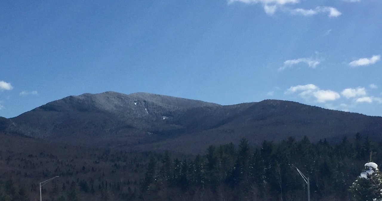
Mount Garfield is 4,500 feet, a summit that sits across the upper Pemigewasset Wilderness looking straight at Franconia Ridge, and it has a reputation among people working through New Hampshire's 48 four-thousand-footers as the easiest of the far-out peaks. That reputation is earned the hard way, and it comes from one thing: the trail. The Garfield Trail was cut as a graded route to a fire lookout that once stood on the summit, so instead of the boulder staircases the White Mountains are known for, you get a steady, moderate, almost road-like grade with long sweeping switchbacks the whole way up. The only steep ground is the last couple of tenths of a mile to the top. What Garfield asks of you is not scrambling or nerve. It asks for distance - about ten miles round trip - and the fitness and daylight to cover it.
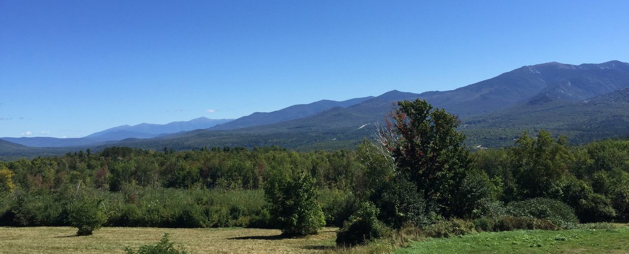
The payoff is a view a lot of hikers rank among the best in the range, and it is a specific one. Garfield stands directly across the deep bowl of the Pemi from the Franconia Ridge, so from the small open summit you get Lafayette, Lincoln, and Little Haystack lined up broadside - arguably the finest head-on look at that ridge anywhere. Turn around and you are staring at the Twin Range, Galehead, the Bonds, Owl's Head sitting low in the wilderness, and, on a clear day, the Presidentials with Mount Washington off to the northeast. Sitting right on the high point is the concrete foundation of the old fire lookout, long since gone. The lookout is not coming back, but the rectangular base remains, and hikers stand and sit inside it - it makes a fine windbreak for lunch and a natural perch for the view.
Here is the practical framing before you plan. Most of Garfield is a walk in the woods on a forgiving grade, which is exactly why it is a good long climb for someone who is fit but not looking to fight the terrain. The real exposure is short - the open summit itself - but that summit is open, and it catches whatever weather is moving through, so this is still a mountain you read the forecast for. The other thing that shapes the day is the road: the trailhead sits on Gale River Loop Road, a seasonal gravel Forest Service road that is gated in winter, and when it is gated the hike gets longer. We are about 30 min away at the lodge, straight up through Franconia Notch, and this is the version we would share with a guest before they left.
The case for Garfield
People climb Garfield for the view, and it is worth being specific about why it is so good, because the reason is position rather than height. At 4,500 feet Garfield is a middling peak on the list, but it sits alone on the western rim of the Pemigewasset Wilderness directly opposite Franconia Ridge, with the deep valley of the Pemi dropping away between them. That geometry hands you the whole Franconia Ridge broadside from the summit - Lafayette, Lincoln, and Little Haystack strung out across the sky - which is a cleaner, more complete look at that ridge than you get from almost anywhere else, including parts of the ridge itself. Around the rest of the compass you get South and North Twin, Galehead close by, the Bonds and Bondcliff, Owl's Head down in the basin, and the Presidentials with Mount Washington on the horizon when the air is clear.
What sets Garfield apart from the other remote 4,000-footers is how it climbs. The Garfield Trail was built as the fire warden's route to the lookout that once stood on top, and it was graded to be walked and worked, not scrambled. That means a steady, moderate pitch, good footing by White Mountain standards, and long switchbacks that keep the grade sane from the parking lot nearly to the summit. There is none of the hand-over-hand rock the Kinsmans or the Beaver Brook side of Moosilauke throw at you. The one exception is the short summit spur at the very end, which finally gets steep for about two tenths of a mile. This is why Garfield gets called the easiest of the far peaks, and the label is fair.
Set your expectations at the right size, though, because the word easy does a lot of quiet damage in these mountains. Garfield is a full committing day - about ten miles and roughly 3,000 feet of climbing, more in winter - in country with limited cell service and no quick way out. The gentle grade makes the climbing pleasant, but ten miles is ten miles, and the second half of the descent is where under-trained legs pay for the distance. It is a poor choice for a first four-thousand-footer and a superb one for someone with a few solid Whites days already in their legs. As for company: on a clear fall Saturday you will share the trail and the summit foundation with a steady stream of peakbaggers, and the lot fills; on a weekday you can have long stretches to yourself. Start early either way, for the parking spot and the weather both.
Gale River Loop Road: the access that sets your mileage (2026)
The Garfield trailhead is not on the Kancamagus and not right off the interstate. It sits on Gale River Loop Road, a gravel Forest Service road that branches off US Route 3 near Twin Mountain and Bethlehem, north of Franconia Notch. In a normal summer the road is open and any passenger car can reach the Garfield Trail lot with a little care over the gravel and washboard. That is the good scenario, and it is the one most people get from late spring, once the road opens for the season, through fall.
The scenario that changes your day is winter. Gale River Loop Road is not maintained or plowed in the cold months - it is gated - so when the gate is down you park out at the plowed end and walk the road to the trailhead before you even start the trail. That road walk adds about 1.2 miles each way, roughly 2.4 miles round trip, which turns the standard ten-mile hike into about 12.4 miles. That is a real difference on a short-daylight day, and it is the single biggest variable in planning a Garfield trip.
Here is the real limit of what this page can do for you. Seasonal Forest Service roads open in late spring and close in fall on dates that move with the year and the weather, and a bad storm can change things, so neither we nor a trail app can promise the road's status on the day you go. Before you commit, check the current status with the White Mountain National Forest, and look at recent trip reports on New England Trail Conditions or a conditions feed for the latest firsthand word. If you cannot confirm the road is open and drivable, plan for the 12.4-mile version or pick another peak that day. Finding out at a gated road wastes the daylight you needed. If you are staying with us, ask before you leave and we will help you make the call with whatever the current word is.
The numbers
Measured the standard way - out and back on the Garfield Trail - Garfield runs right around ten miles, with the trail about five miles each way to the summit spur. When Gale River Loop Road is gated and you walk the road, call it about 12.4 miles. The Garfield Trail meets the Garfield Ridge Trail, which carries the Appalachian Trail here, at 4.8 miles, and from that junction a short, steep spur of about two tenths of a mile climbs to the actual summit.
The elevation gain is usually given as about 3,000 feet, and I want to be straight with you about that number. The ten-mile distance, the 4,500-foot summit, the road access and its winter mileage, and the 4.8-mile trail junction are well established. The exact gain figure, though, wanders from source to source and from one GPS track to the next, as it always does in these mountains - you will see it put anywhere from roughly 2,900 to 3,050 feet. If you want the precise number your map uses, check the current AMC White Mountain Guide before you go, and treat any single figure as approximate. What is not in doubt is the shape of the day: a long, steady climb, not a wall.
Carry the summit height in your head with a small asterisk, the same way you would for other peaks on the list. Garfield is listed at 4,500 feet on the Appalachian Mountain Club's four-thousand-footer list, and that is the figure you will see on trail signs and patches. The 4,500 figure is the traditional one the club uses. It places Garfield in the middle of New Hampshire's 48 four-thousand-footers.
For timing, plan on a full day. Most fit parties are looking at six to eight hours car to car for the ten-mile round trip, including breaks and time on the summit, and more when the road adds the winter miles. A strong hiker moving well can do it faster; a careful group or a first big day can be out longer. File Garfield as moderate by grade but long by distance and non-technical: the footing is fair, there is no exposed scrambling beyond the short summit pitch, and the difficulty is simply covering the miles - especially on the descent.
Why the grade is so kind: the old fire-warden's trail
The reason Garfield climbs so gently is history you can feel underfoot. The summit once held a fire lookout, and the Garfield Trail is essentially the graded route that was built to reach and service it - a wide, steady, tractor-road grade laid out with long switchbacks so a person could walk and work it rather than scramble. Decades of hiking traffic have kept it open, and while it has the roots and rock any old White Mountain path collects, the underlying grade is the giveaway: it climbs at a consistent, moderate pitch instead of lunging up the fall line the way trails cut straight to a peak tend to.
What that means for you is a climb you can settle into a rhythm on. The trail works up through hardwoods and then into spruce and fir, gaining elevation the whole time, but without the knee-and-hand pitches that make some Whites climbs a fight. You make steady, satisfying progress. Only the final two tenths of a mile, the summit spur off the ridge trail, steepens and gets rocky. If you have done a rougher four-thousand-footer already, Garfield will feel almost civilized by comparison for most of its length.
The practical upshot is where the risk lives on this mountain. Because the grade is forgiving and there is no technical crux, the thing that gets people into trouble here is not a slip on a ledge - it is running low on fuel and water on a long walk, and running out of daylight on the ten-mile round trip. Pace yourself to the distance, eat and drink before you feel you need to, and keep a practical eye on the clock. A steady, well-fed hiker has a lovely day on Garfield; a fast start followed by a bonk five miles from the car is the classic way to make it miserable.
The trailhead, parking, and the fee
The Garfield Trail lot on Gale River Loop Road is a standard Forest Service trailhead - a gravel lot, a trail sign, and not much else. There are no facilities to speak of and no water you would want to rely on, so handle both before you arrive. It is a reasonable size, but it fills on clear fall weekends, so an early start does double duty: better light and weather odds, and an actual parking spot rather than a scramble along the shoulder.
Like most White Mountain National Forest trailheads, this one falls under the WMNF recreation pass. For 2026 that is about $5 for a day pass, good the day you buy it; $30 for an annual pass or $40 for an annual household pass covering two vehicles; and the $80 America the Beautiful interagency pass covers it too if you already carry one. There is usually a self-serve station where you fill out an envelope and display the stub on your dash. Rates and requirements can change, so confirm the current fee on the Forest Service website - and if you are hitting several trailheads on your trip, the annual pass usually pays for itself.
One navigation note for the top of the climb, because it is the junction that matters. At 4.8 miles the Garfield Trail ends where it meets the Garfield Ridge Trail, which carries the Appalachian Trail along the crest here. To reach the summit you follow the signs uphill onto the short, steep summit spur - about two tenths of a mile of the only real climbing of the day - to the open top and its foundation. The Garfield Ridge Trail running off along the crest leads to Garfield Ridge Campsite and, farther on, toward Galehead Hut in one direction and Franconia Ridge in the other. In summer this reads clearly; under snow, know the junction is coming so you turn the right way with a long day still ahead of you.
The route, mile by mile
The first stretch out of the lot is the gentlest of the whole hike. The Garfield Trail crosses the South Branch of the Gale River early on and works up easy grades through hardwood forest, roughly paralleling the drainage as it climbs. In summer this is a warmup you barely notice, and it lulls you into thinking the day will be effortless. Read that river crossing as you go, though - it gets its own section below - because in high water this easy opening is exactly where a Garfield day can end before it really starts.
After the easy start the trail settles into its long, graded middle, and this is the heart of the climb. Switchback after switchback works up the north slope of the mountain at that steady, moderate pitch, with the hardwoods giving way to spruce and fir as you gain height. Nearly all of your elevation gets earned in this section, but it is earned kindly - a grind of distance more than a battle with steepness. Pace yourself here rather than burning your legs, because you have the full descent of this same trail waiting for you.
At 4.8 miles you reach the Garfield Ridge Trail junction just below the summit, and the character of the day finally changes. The summit spur is a short, steep, rocky pitch of about two tenths of a mile - the one steep stretch of the route - and it delivers you onto the small open top. This is where you slow down, because after miles of forgiving grade the sudden steep rock can catch tired or careless feet, especially coming back down it.
From the summit you take in the foundation and the view, then turn around and descend the same trail you climbed. The descent is easy on the feet by White Mountain standards - that is the graded trail paying you back - but it is long, and the miles add up on a body that has already climbed. Watch the light, keep eating and drinking, and remember you still have the South Branch of the Gale River to re-cross low down, possibly running higher than it was in the morning if the day warmed up or a storm rolled through while you were up top.
The summit, the fire-lookout foundation, and the view
The top of Garfield is a small open rocky knob, and sitting right on the high point is the concrete foundation of the fire lookout that once stood here. The lookout itself is long gone - the Forest Service ran lookouts on peaks like this in the middle of the last century and removed most of them decades ago - but the rectangular concrete base remains, and it has become the summit's signature. Hikers stand and sit inside it. It makes a natural windbreak for lunch and a raised platform for taking in the view, and it is the thing people remember and photograph up here.
The view is the whole reason to make the ten-mile round trip, and it lives up to the walk. Garfield looks straight across the upper Pemigewasset Wilderness at Franconia Ridge, with Lafayette, Lincoln, and Little Haystack strung out broadside - the cleanest head-on look at that ridge you will find. Swing around and you take in the Twin Range with South and North Twin, Galehead close at hand, the Bonds and Bondcliff, Owl's Head sitting low in the basin, and, when the air is clear, the Presidential Range with Mount Washington off to the northeast. It is a genuine wilderness panorama, and because Garfield sits where it does, the marquee piece of it is that ridge.
A couple of practical points follow from all this. Because the summit is open and small, the view is right there in the open, with nothing left of the old lookout but its foundation - but that same openness means you are exposed to whatever the wind is doing the moment you top out. Bring a warm layer even in summer; a breezy 4,500-foot summit cools you off fast once you stop moving and start eating. And on a socked-in day the payoff simply is not there, so if you are chasing that Franconia Ridge view specifically, save Garfield for a clear one.
Weather, exposure, and the higher-summits forecast
Most trouble in the White Mountains starts when the weather turns and hikers are dressed for the parking lot. Garfield is less exposed than the big ridge walks - most of it is a wooded climb - but the summit is open, and it makes its own weather. It can be sunny at the car and socked in with cold wind-driven cloud on top the same morning, and the temperature difference between the trailhead and that bare summit can be startling. The short exposure is real exposure while you are in it.
Before you go, read the Mount Washington Observatory Higher Summits Forecast. It is the go-to forecast for the White Mountains up high, and while Garfield is neither as tall nor as bald as the Presidentials, that forecast is still the best read on wind, temperature, and incoming weather for the elevation you will be standing at on the summit. Pair it with an ordinary valley forecast for the Twin Mountain or Franconia area so you know what you are driving into as well as what you are climbing into. If the higher-summits forecast is calling for high wind, freezing levels dropping onto the peaks, or thunderstorms, that is your answer for the day.
Two timing rules earn their keep here. First, thunderstorms in the Whites build in the afternoon, and a small open summit is a bad place to be with lightning around - so get up and down early, and if storms are building, do not linger on top. Second, this is a ten-mile day, twelve and a half in winter, so start at first light and you will not be making decisions in fading light with tired legs and a cold river crossing still ahead of you. Carry a headlamp regardless; everyone who has ever been caught out after dark meant to be down by then. The forecast is one tool, not a guarantee - be ready to make your own call from what the mountain is doing, and if in doubt, turn around.
Water crossings and the brooks
The Garfield Trail is not a route known for big fords the way some Pemigewasset Wilderness trails are, but it does cross the South Branch of the Gale River low down, and that crossing deserves some attention in high-water season. In normal summer flow it is a rock-hop you will clear without wet feet, which is why it does not get much ink. That is the version most people meet, and if that is your day, note it and move on. But do not assume it, because the same crossing behaves very differently under different water.
After heavy rain, during spring snowmelt, or when the snowpack up high is letting go, that crossing runs fast, cold, and higher than you would expect. Moving water at that level is a genuine hazard - it does not take much depth or much current to put you off your feet, and this is cold mountain water, not a warm swimming hole. The smart move is to treat that first crossing as a test. If you are uneasy getting across dry in the morning, remember it will likely be higher on the way back after a day of melt or afternoon rain, and the far side is where you will be tired and ready to be careless.
So we will say it, because this is the kind of decision that saves people: if the water is high, this is not the day for Garfield, and the summit will be there next month. Do not cross fast water you are not sure of, and never cross where a slip would put you into a rapid or a jam of debris. Check recent trip reports for the state of the crossing before you drive out, and if the forecast has thunderstorms, plan around the fact that a dry crossing at eight in the morning can be a problem crossing at four in the afternoon.
Garfield Ridge Campsite and the ridge beyond
A short distance off the summit, on the Garfield Ridge Trail where it carries the Appalachian Trail, sits Garfield Ridge Campsite - a backcountry site managed by the Appalachian Mountain Club, with a shelter and wooden tent platforms and, in the warm season, a caretaker on site. It exists mainly for Appalachian Trail hikers passing through and for people making Garfield part of a longer ridge trip, not for the standard day hike, but it is worth knowing about, both as a landmark near the top and as an option if you ever want to build an overnight around this peak.
If you do plan to stay, the AMC collects a modest per-person overnight fee at the site, and there is a water source nearby. I am not going to quote you an exact 2026 price, because backcountry-campsite fees and seasons shift year to year and the smart move is to have you confirm the current fee, the operating dates, and whether space is first-come directly with the AMC before you count on it. These sites fill on summer weekends. Wherever you camp up here, bear-aware food storage is the rule, and standard backcountry-camping setbacks from the trail and water apply.
The ridge beyond the summit is worth understanding even if you never set foot on it today. From the top the Garfield Ridge Trail runs west past Garfield Pond - a small pond roughly half a mile beyond the summit - toward Mount Lafayette and Franconia Ridge, and the other way it drops steeply and then climbs toward Galehead Hut and the Twin Range. Both directions are serious, rugged trail; the Garfield Ridge Trail has a well-earned reputation as one of the rougher, more tiring stretches of the Appalachian Trail in New Hampshire. None of it is part of the Garfield day hike, and it is not the kind of terrain to wander onto off the summit on a whim. It is a long, hard way to anywhere, and the return by the way you came is the plan.
Winter and mud season - a different mountain
In winter Garfield becomes a bigger undertaking, and mostly because the access changes rather than the summit. Gale River Loop Road is gated and unplowed, so you add about 1.2 miles of road walking each way before you even reach the trailhead, turning it into roughly a 12.4-mile day. The good news is that the graded trail holds snow well and packs out nicely under snowshoe traffic, the low river crossing is often frozen or bridged with snow, and the winter summit can hand you the clearest Franconia Ridge view of the whole year. Because of that gentle grade, Garfield is one of the friendlier winter four-thousand-footers on the list.
Friendlier is not the same as easy, though, and winter here is a full-value day. You want snowshoes or the day's correct traction, real winter layers with backups, a headlamp and spare batteries, and the fitness to cover twelve-plus snowy miles inside short daylight. The open summit is wintry even when the valley is mild - wind and cold with nothing to break them - so treat the top as the exposed place it is, get your layers on before you step out of the trees, and be ready to take the view quickly and drop back down. This is not a first winter hike, and the road walk at each end eats daylight you will want back.
The other season to respect is spring. Mud season - roughly April into May - is often the worst time to go. The road may still be gated, the trail is soft enough that boots chew it up, and the South Branch of the Gale River runs its highest of the year on snowmelt, which makes the crossing the hardest it gets. The Forest Service asks hikers to stay off high-elevation trails during mud season to protect them from erosion, and the crossing alone is reason enough to wait. For most visitors, summer through mid-fall is the right window for Garfield, with fall foliage the prime time - cold on top, but hard to beat for that ridge view.
Difficulty and turnaround judgment
On paper the Garfield Trail is graded moderate - fair footing, a steady pitch, and no exposed scrambling beyond the short summit spur. What makes Garfield a real day is simple distance and gain: about ten miles and 3,000 feet, or 12.4 miles when the road is gated. If your recent hikes top out at three or four miles, this is a big step up, and the back half of the descent is where under-trained legs feel it. Be clear-eyed about that before you are five miles from the car with a long way back.
A useful rule for the Whites is to plan on roughly a mile every half hour on the easier grades and slower on the climb - most fit parties are looking at six to eight hours car to car with breaks and time on top. Set a turnaround time before you start: pick the hour by which you must be heading down regardless of how close the summit feels, based on your daylight, your fitness, and the state of the crossing. Then honor it. The summit is optional; getting back to the car in one piece is not.
This is a great hike for someone with a few solid White Mountain days already in their legs who wants a long, rewarding climb without technical scrambling - the easiest of the remote peaks, as long as you respect the ten miles. It is a poor choice for a first big hike, for a late start, or for a socked-in day when the head-on Franconia Ridge view, the entire reason to climb Garfield rather than something closer, will not be there anyway. When in doubt, the mountains reward the patient. We would rather you came back for a clear day and got the view you drove for than gutted out a viewless slog and called it a win.
What to carry, dogs, hikeSafe, and the rescue law
Carry the ten essentials every time, even in perfect weather: navigation (a paper map and compass, plus a downloaded map on your phone, since cell service out here is spotty), a headlamp, sun protection, insulation beyond what you are wearing, a first-aid kit, a knife or repair kit, fire-starting means, extra food, extra water or a way to treat it, and emergency shelter. For a ten-plus-mile day, lean toward more water and more food than you think you need - two to three liters is a reasonable starting point, more in heat - and know the 4.8-mile junction where the summit spur climbs off the Garfield Ridge Trail so you turn the right way in poor visibility or snow.
Dogs are allowed on the Garfield Trail, as on most White Mountain National Forest trails - there is no leash law in the forest itself, but keeping a dog leashed or under tight voice control is the courteous and safe choice, especially at the river crossing and around other hikers. Be realistic about your dog on this route, though: ten miles, a cold crossing, and a small open summit that gets wind and cold. Bring water and food for the dog, watch their paws on the steep summit rock, and turn around for their sake in high water exactly as you would for your own. One note for our guests, since people ask: the lodge is adults-only and pet-free, so hiking with a dog means other overnight arrangements.
New Hampshire has two things worth keeping in your pocket. The hikeSafe card, sold through New Hampshire Fish and Game, is a voluntary card that generally means you will not be billed for the cost of a search or rescue if you need one, a small, smart purchase for anyone who hikes here regularly. And the reason it matters: New Hampshire can bill hikers for the cost of their rescue when the person was negligent, under state law (RSA 206:26-bb). The card protects you from the ordinary case, but not from reckless choices like crossing a raging brook you were warned about or heading up into a lightning forecast. The law and the card point the same direction: prepare, check conditions, and turn around when the mountain tells you to.
One low-tech habit does more for your safety than any gadget: tell someone your plan and your expected return time before you leave, and check in when you are down. Leave it with a friend or someone at home - who is going, which trail, and when to worry. Pack out everything you pack in, stay on the footway, and give the summit and its foundation to the next party in the shape you would want to find them. And if your legs have anything left on the drive home, the Basin - a short, flat roadside stop right off the parkway in Franconia Notch - makes an easy coda, and Lonesome Lake, a short but uphill hike to a mountain pond, is a good rest-day plan for the day after.
Safety & conditions
- Check Gale River Loop Road's status before you drive out. It is seasonal - gated and unplowed in winter - and when it is gated the hike becomes about 12.4 miles. Confirm with the White Mountain National Forest and recent trip reports, and plan for the longer day if you cannot confirm the road is open, so you are not discovering it at a locked gate with your daylight already spent.
- Read the Mount Washington Observatory Higher Summits Forecast the morning you go, alongside a valley forecast for the Twin Mountain or Franconia area. Garfield's summit is open and makes its own weather; high wind, dropping freezing levels, or thunderstorms on that forecast are a no, even though most of the climb is sheltered woods.
- Treat the South Branch of the Gale River crossing, low down, as a go/no-go. Easy in summer, but in high water or spring melt it runs fast and cold enough to knock you off your feet. If it is high in the morning it will likely be higher on your tired return, so turn around here if you have to, and never cross water you are unsure of or where a slip sends you into a rapid.
- Get up and down early to beat afternoon thunderstorms - a small open summit is a bad place for lightning - and because this is a ten-mile day, twelve and a half in winter. Carry a headlamp even for a day hike; the descent is long and the light goes fast, and everyone caught out after dark meant to be down by then.
- Set a turnaround time before you start and honor it regardless of how close the summit feels. Garfield is the easiest of the remote peaks by grade, but distance is what to plan for here - the long descent at the end of a ten-mile day is where tired legs feel the climb. Getting back to the car matters more than the last half mile up.
- Carry the ten essentials plus two to three liters of water and extra food. Cell service is spotty - download offline maps and carry a paper map and compass, and know the 4.8-mile junction where the summit spur climbs off the Garfield Ridge Trail, so you turn the right way in poor visibility or snow.
- Bring a warm layer even in summer. The summit is open and exposed, and a breezy 4,500-foot top chills you fast once you stop moving to eat - the temperature up there can be far colder than at the car, and the wind has nothing to break it.
- Respect winter and mud season. In winter the gated road adds the road walk (about 12.4 miles total) and the open summit is wintry - a full day for experienced, well-equipped parties only. Spring runs the river crossing at its highest on snowmelt; for most people, wait for summer through mid-fall.
- Consider the hikeSafe card from New Hampshire Fish and Game. It generally spares you the rescue costs New Hampshire can bill to a negligent hiker under RSA 206:26-bb, though not after a reckless choice, so think of it as a backstop rather than a license to take risks. Tell someone your route and expected return time before you leave, and check in when you are down.
Where to stay for it
From the lodge at 191 Pollard Road, Garfield is one of our closer big-mountain trailheads - about 30 min. You head north on I-93, the Franconia Notch Parkway, straight through Franconia Notch past Lafayette Place and Cannon, out the north end, and continue to Exit 35 for US Route 3 toward Twin Mountain. From US Route 3 it is a short run onto Gale River Loop Road, a gravel Forest Service road, to the Garfield Trail lot. The last roads are small and easy to miss, so watch your map on the final turns, and remember that Gale River Loop Road is gated in winter - when it is, you park at the plowed end and walk the road, which adds the extra miles to your day.
Gas up and grab food in Lincoln before you leave. There is a supermarket and convenience stores near Exit 32, and once you are north of the Notch the services thin out fast - do not count on anything at the trailhead, which has none. For a day this long we would point you toward an early breakfast and a packed lunch rather than counting on finding something along the way. If you want an easy add-on on the drive back, the Basin is a short, flat roadside stop right off the parkway in Franconia Notch - a fine coda if your legs have anything left - with Lonesome Lake, a short but uphill walk to a mountain pond, nearby for a day with more in the tank.
Sources & official info: 4000footers.com · outdoors.org · mountwashington.org · hikesafe.com · fs.usda.gov
— Launchpoint Lodge, From the lodge